Friday, January 15, 2021 at 8:02 AM •
Inovia lands
•
Terre-net Media
Today drones are able to map areas infested by weeds. To limit the surface treated, and therefore the quantities of herbicides used, the idea of spraying only these spots deserved to be tested and evaluated. Feedback from Terres Inovia on a targeted spraying test on weeds detected by drone in rapeseed.
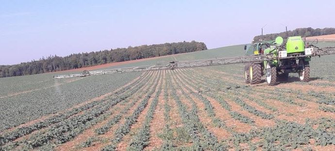
Terres Inovia takes stock of its targeted spraying test on weeds detected by drone in rapeseed plots. (© Terres Inovia)
Au within the European H2020 project IWMPRAISE, Inovia lands and his partner AgroSup Dijon have set up in collaboration with Airinov then Delair and Berthoud, two trials on rapeseed, for evaluate targeted spraying on the tasks of weeds, previously detected by drone. Indeed, the production chain is long and it is necessary to check that everything is feasible and well coordinated.
 |
 |
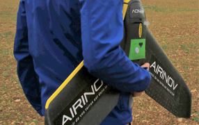
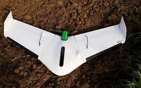
| Airinov drone, used for the 1 is test (flying wing carrying a multispectral camera) | Delair drone, used for the 2 nd test (UX11) |
| (© Terres Inovia) | |
In practice, the drone passes over the plot of a rapeseed field sown at wide spacing (60 cm) at about the 4-leaf stage, the areas infested with weeds are then identified. Taking into account areas to be treated depends on rate of weeds present in the inter-row. The resulting treatment card is produced within a few days of the flight. Introduced into the sprayer console at about the 6 leaf stage of the rapeseed, it will allow cut the sections of the boom above the areas not to be treated, for’optimize the herbicide treatment. The effectiveness of weeding is ultimately evaluated: are weed spots well weeded? Do the areas not to be treated get dirty during the cycle?
Two Dijon trials: with Airinov in 2018-2019, with Delair in 2019-2020
The objectives of these two exploratory trials were to verify: the feasibility, effectiveness, interest, relevance and environmental gain of such a technique.
To judge the relevance of the service, the results obtained by drone were compared with surveys of field flora on dedicated plots. Theweeding efficiency (final satisfaction) was estimated a posteriori. The environmental gain linked to the reduction of the treated surface has been quantified. In addition, the organization of the site, the deadlines, the evaluation of the strategies and the risk taken in each operation were studied.
 Calendar of interventions and observations. (© Terres Inovia)
The interest of this technique is reserved for certain situations
In these two trials, the entire logistics chain could be deployed, the weeds present on the interang were clearly identified and the detection map was found to be consistent with the observations in the field. However, the plots of the two trials exhibited a significant rate of weed coverage but a rather homogeneous distribution, not leaving many large areas free of weeds.
As a result, the recommendation map was made up of few areas that should not be sprayed. This explains a rather limited reduction in the treated surface (18% in the first test compared to a “classic” treatment on the entire plot) and reduces the economic and environmental interest of the service. Thus, for treatment targeting to be relevant and cost effective, a weed infestation threshold should be characterized, or more precisely a distribution of the infestation from which the use of this technology is justified.
Thus, these tests have shown that a treatment solution targeted at the infested areas from data acquired with a drone is possible; however, certain conditions are required:
- A establishment of rapeseed at large spacing (60 cm) so that the row structure can be detected by the drone;
- When the drone is in flight, the rapeseed must offer sufficient ground cover (sufficiently advanced stage) given the acquisition resolution of the drone;
- Likewise, weeds must be sufficiently developed to be detected;
- A non-uniform or heterogeneous weed infestation.
On the other hand, these tests highlighted several elements that still need to be improved:
- Limit the time between the drone shooting and the herbicide treatment in order to position the treatment as close as possible to the drone flight, take into account the latest weed emergence and take advantage of the optimal weather conditions for spraying as soon as they arise;
- Configure the translation of the detection map into an application map to ensure that it is relevant, optimized and compatible with the operation of the sprayer in the field (console format, positioning of section cuts, erosion of isolated weeds, buffer around the weeds concerned according to the triggering time and GPS accuracy, etc.);
- Characterize the field situations for which the modulation carried out in this way presents a economic interest for the farmer because this technology is not suitable for all plots.
To generate the treatment map, it is necessary to take into account:
– the differences in the geolocation of the GPS of the drone and the tractor;
– the forward speed of the tractor;
– the opening time of the nozzles at the time of treatment.
There are also choices to be made:
– remove small weed spots;
– delimit the sections of the sprayer according to the tractor passages on the plot;
– the latency time between sending the opening command and the actual opening of the sprayer boom nozzles is also to be configured in the console and to be assessed according to the risk linked to the type of infestation for the crop. To take the least risk, it is necessary to select the least restrictive coefficient in order to obtain an early start and a late closing of the boom.
Despite these precautions, there may be “false negatives”, that is to say areas that were not treated when they were infested (too late triggering of the boom) or “false positives”, that is to say areas treated then. that this did not seem necessary according to the mapping of the drone (effect of overlaps between buffers and the timing of section openings).
–
© All reproduction rights reserved – Contact Terre-net
–
