<!–enpproperty 360476312022-09-26 08:24:40.0
1. Weather
1. Domestic situation:Light to moderate rains occurred yesterday in Tibet, Sichuan, Yunnan and other places heavy local rains
From 08:00 yesterday to 06:00 today, parts of southeastern Gansu, eastern Tibet, southern Sichuan, western Yunnan, and southern island of Hainan have experienced mild to moderate rains and heavy local rains. . Compared to yesterday’s 5 o’clock, northeastern Inner Mongolia, western Heilongjiang, western Jilin, western Liaoning and other places experienced a temperature drop of 4-6 ° C and local cooling was 8-10 ° C .
2. Live abroad
(1) Heavy rainfall in Japan, India, Brazil and other places
Moderate to heavy rains occurred in parts of Northern Japan, Southeast Far East, Southern Russia, Northern India, Indochina Peninsula, Southeast Asia, Southern Eastern Europe, Eastern Europe, the Labrador Peninsula, Southern Mexico, Northern South America, Central Brazil and Central Africa, heavy local rains or heavy rains, accompanied by strong convective climate such as thunderstorms and strong winds.
(2)High temperatures in the southern United States, northern Australia and other places
Arabian Peninsula, Mesopotamia Plain, Iranian Plateau, South Central Asia, Indus Plain, South Indian Peninsula, Sahara and its North, South Africa, Southern United States, Northern Mexico, Northern Brazil, Northern Australia, etc. With high temperatures, the highest the temperature reaches 35-38 ° C and the local surface exceeds 40 ° C.
Second, the key weather forecast
1 、Home key weather
(1)Strong typhoon “Olu” has entered the South China Sea
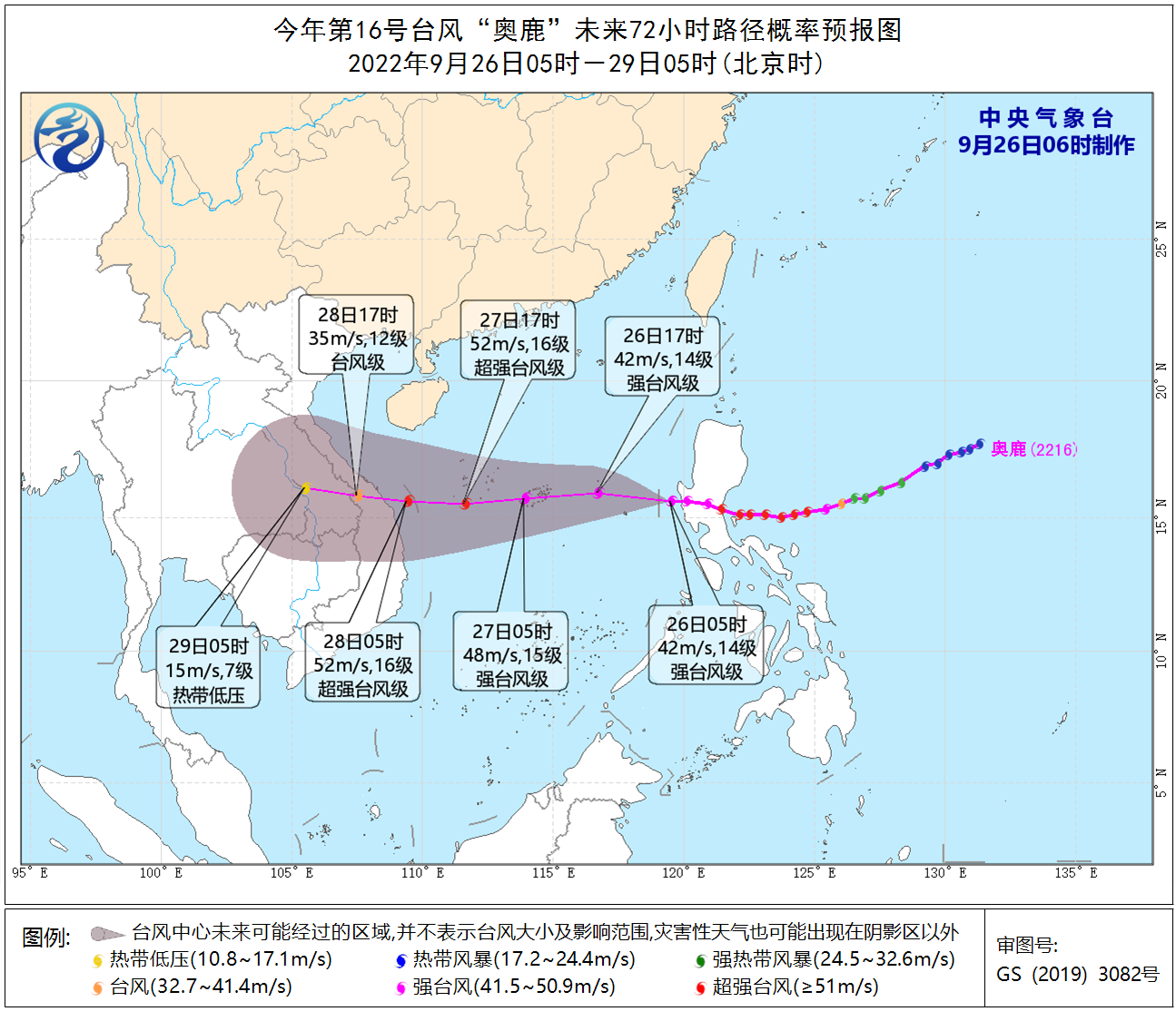
Typhoon No. 16 of this year “Olu” landed on the coast of the province of Aurora, in the island of eastern Luzon, in the Philippines, around 20:00 yesterday (25). The maximum wind strength near the center was 16 (55 m / s, super strong) Typhoon level), the lowest pressure in the center is 930 hPa. After landing, he moved in a west-north direction and crossed the island of Luzon in the Philippines. The intensity has weakened from the super typhoon level to the strong typhoon level. Today (26) morning from the Philippines Luzon The island moved into the sea in the central and eastern part of the South China Sea.At 5 am, its center was located on the surface of the central and eastern part of the South China Sea, approximately 195 kilometers northeast of Huangyan Island in my country. It is expected that “Olu” will move west at a speed of between 25 and 30 kilometers per hour, gradually approaching the east coast of Vietnam and the intensity will be strengthened. Seconds, 15 to 16, strong typhoon level or super typhoon level), the intensity quickly weakened after landing (see Figure 1). The Central Meteorological Observatory issued a yellow typhoon warning at 06:00 on September 26。
Affected by the cold air and “Aolu”, from 08:00 on the 26th to 08:00 on the 27th, the coastal areas of Fujian, Guangdong, the east coast of the island of Hainan, the west coast of the island of Taiwan, as well as the Taiwan Strait, the Bashi Strait, most of the South China Sea, three There will be winds of magnitude 6 to 7 and gusts of magnitude 8 to 9 in the waters near the Sand Islands, including the central waters of the Sea South China, the Xisha Islands and the waters near the Zhongsha Islands will have winds of magnitude 8-12 and gusts of magnitude 13-14. The wind in the sea area is 13-16, and the gusts are 17 and above; there will be heavy rain or heavy rain in the Sansha Islands and some islands will have heavy rain (100-130mm).
Figure 1 Forecast map of the probability of typhoon “Olu” in the next 72 hours
(2)Cloudy and rainy in the southwest
From the 26th to the 27th it was rainy and rainy in the southwest. There was light to moderate rain, local heavy rain or heavy rain in some parts of Sichuan, Chongqing, Yunnan, Guizhou, the Qinghai-Tibet Plateau and other places; sleet or snow in high altitude areas.
2. Foreign key weather
(1)There will be heavy rainfall on the Indochina Peninsula, Eastern Europe and other places
In the next three days, the islands of Japan, Southern Russia, Southern India, Indochina, Southeast Asia, Northern Western Europe, Central Western Europe, Central Europe, Southern Europe Eastern, Central Eastern Europe, Western Canada, Labrador Peninsula, Florida Peninsula, Southern Mexico and Central Africa, Northern South America, Southern Brazil and other places have moderate to heavy rainfall, heavy rain intense to strong locales and some areas are accompanied by strong convective weather conditions such as thunderstorms and strong winds. Moderate to heavy snowfall or snowfall in central Russia, Alaska, and northern Canada.
(2)Western AsiaContinuous high temperatures in North Africa, the southwestern United States and other places
Over the next three days there will be high temperatures above 35 ° C in parts of Western Asia, South Central Asia, the Indus Plain, the Southwestern United States, Northern Mexico, Northern Australia, the Sahara and its northern regions, and eastern Brazil The maximum temperature will exceed 40 ° C.
3. Specific forecast for the next three days
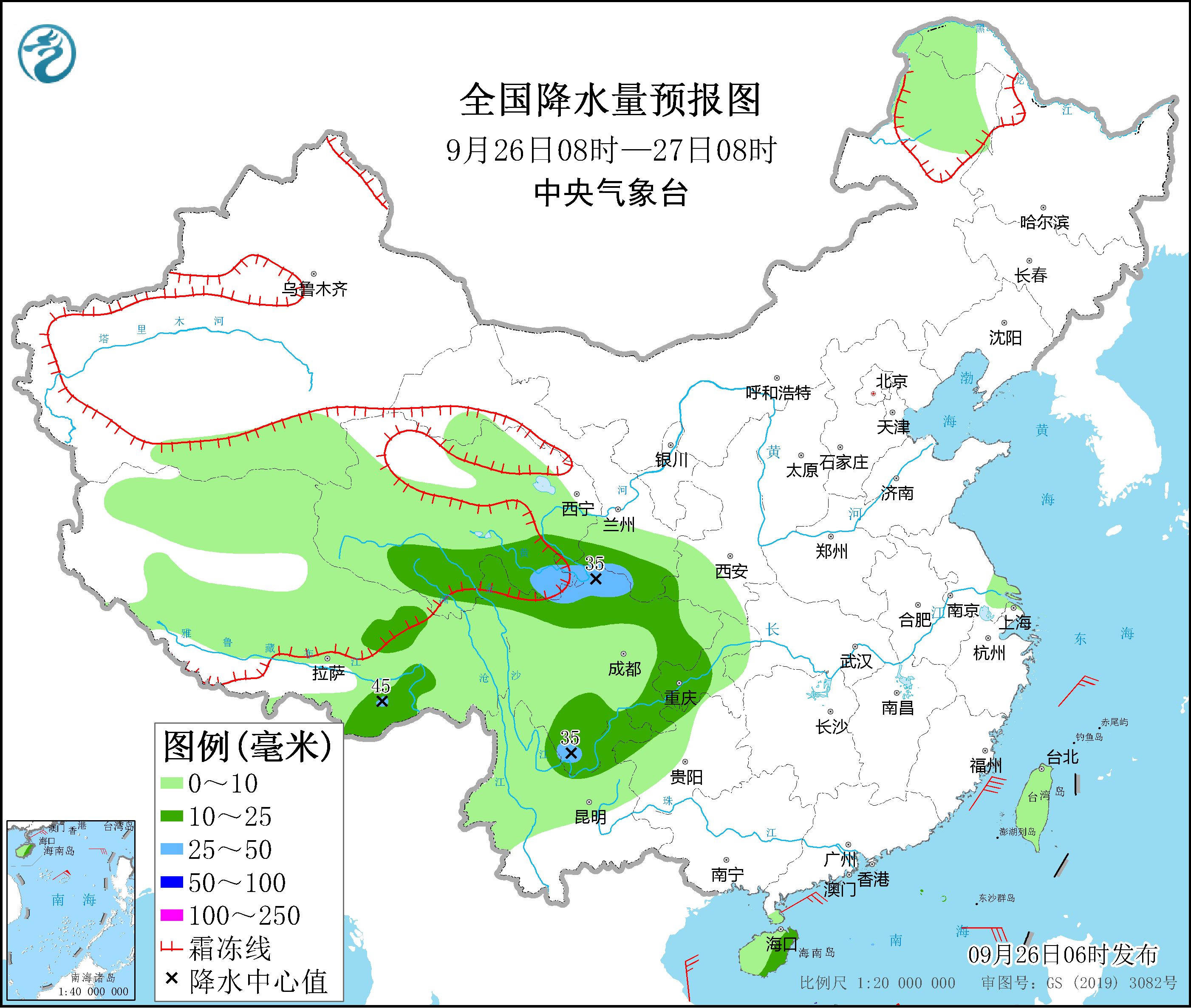
From 08:00 on 26 September to 08:00 on 27,There is light to moderate rainfall in parts of Tibet, Qinghai, southern Gansu, southwest Shaanxi, Sichuan, Chongqing, Guizhou, Yunnan, Hainan, and Taiwan, including Southeast Tibet, Southeast Qinghai, South Gansu, North Sichuan Plateau, Sichuan . heavy local rains in the south and elsewhere (see figure 2). There will be winds of magnitude 11-12 and gusts of magnitude 13 in the South China Sea.

Figure 2 National precipitation forecast map (08:00 on 26 September – 08:00 on 27)
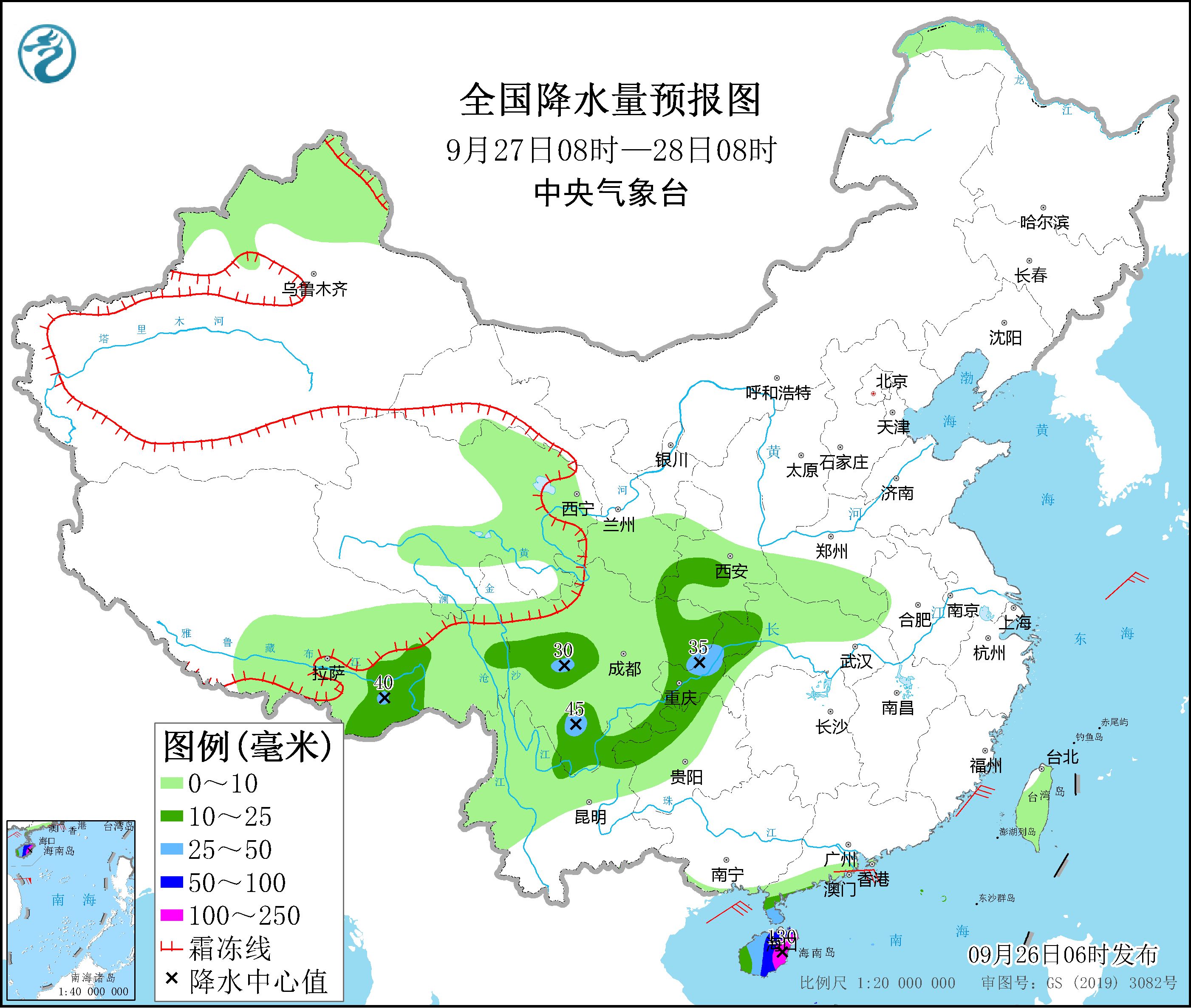
From 08:00 on 27 September to 08:00 on 28,There is moderate to heavy rainfall in parts of Southeast Tibet, Southern Shaanxi, West Sichuan Plateau, Chongqing, West Guizhou, Hainan and other places, including heavy rain in parts of the island east of Hainan and other places, and local heavy rainfall (100-130 mm) (see figure) 3). There will be winds of magnitude 12-14 and gusts of magnitude 15 in the central and western waters of the South China Sea.

Figure 3 National precipitation forecast map (08:00 on 27 September – 08:00 on 28 September)
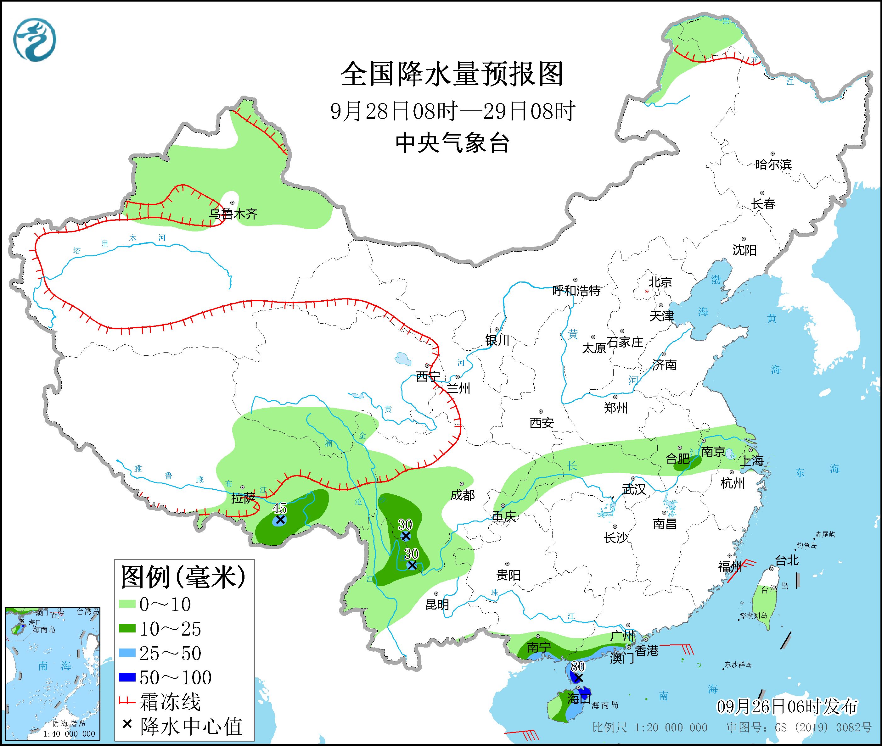
From 08:00 on 28 September to 08:00 on 29,Moderate to heavy rainfall has occurred in parts of southeastern Tibet, the South Sichuan Plateau, North Yunnan, the South Coast of South China and Hainan. Among these, there were local torrential rains (50-80 mm) along the coast of southern Guangdong and northeastern Hainan Island (see Figure 4). There will be winds of magnitude 9-11 and gusts of magnitude 12 in the central and western waters of the South China Sea, and there will be winds of magnitude 7-8 and gusts of magnitude 9 in the Gulf of Beibu.

Figure 4 National precipitation forecast map (08:00 on 28 September – 08:00 on 29 September)
4. Influence and concern
(1) Pay attention to the development of typhoon “Olu” and its impact on the South China Sea and coastal areas of South China;
(2) Pay attention to secondary disasters that can be caused by continuous rains in the southwestern region and short-term strong local rains and its impact on the Sichuan-Tibet railway and Luding seismic area.
To do:Zhang Zanna Ushiwaka art Huang Yiwu Zhang Lisheng issued: Zhang Tao
[
责编:杨煜 ]
–


