–
–
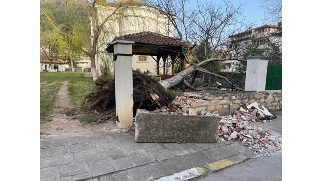
The wind in Vratsa felled some of the trees and even left the city in a state of emergency for a short time.
–
An ice front is replacing the Sahara storm that is raging in the Balkans.
Hurricane wind left settlements in the municipality of Vratsa in a state of emergency and for a short time – without electricity.
Gusts up to 160 km / h
they smashed chimneys, billboards, sheds, car windows and buildings and toppled the city’s iconic half-century-old spruce trees in front of the theater.
In Sofia, a man survived under a heavy branch that collapsed on him in the park in the Holy Trinity district. Due to pain in the ribs he was taken to “Pirogov”, there is no danger to his life. Two other cars were hit by fallen trees under which they passed.
The southern districts of the capital are the most affected, there are over 120 signals submitted to the emergency services
The sandstorm in Athens covered the Greek capital in thick clouds and hid even the iconic Acropolis.
The weather over Europe is dynamic and there are several low pressure centers in the southeastern part of the continent.
Series of Mediterranean sea cyclones
passes from the Gulf of Genoa through Hungary to Ukraine. The Balkan Peninsula is in the warm part of these cyclones and the transport of air masses is from southwest to northeast. It is there that the transfer of Saharan particles from North Africa to Southeast and Eastern Europe takes place, explained for “24 Hours” the climatologist from Sofia University Dr. Simeon Matev.
“This is not a rare situation. Several times a year, such a transfer of particles from the Sahara is possible. We call the first rain after such a phenomenon muddy or brown, “he added.
2 weeks ago a similar situation in Western Europe
colored all winter resorts on France, Spain and Switzerland
and the illusion was created that skiers were driving on sand.
A well-defined cold atmospheric front will pass through the country on Saturday evening and on the night before Sunday from west to east, which will put an end to the Saharan inclusion.
In many places it will thunder and rain.
At first the rain will be colorful, but with the accommodation of a cool air mass from the North Atlantic Ocean it will clear up. This will lower the temperatures and if on Friday in many places it was between 20 and 25 degrees, then on Sunday the maximum will be between 10 and 15.
It is possible that in addition to the mountainous areas, snow will also fall in the lower places. It is possible that the rain will temporarily pass into
snow and on high neighborhoods of Sofia
“There will be no snow cover in the lowlands, but in the mountains over 1,000 meters it will be a real winter,” Matev explained.
Monday morning will be cold. The minimum temperatures in some places will be close to zero and frosts will form. During the day it will be cool – from 11 ° to 16 °. It will be sunny before noon, but it will be cloudy in the afternoon. On the night before Tuesday and Tuesday in some places, mainly in southern Bulgaria, it will rain again for a short time. On Wednesday there will be sun, clouds and short-term precipitation around the mountains. Southwest wind will appear again and it will warm up to 14-19 degrees.
On Thursday, after a warm morning, a new cold front enters. It will rain in many places, it may thunder. However, this cooling will be short-lived, because on Friday the precipitation will stop quickly and it will warm up.
“A dynamic week is ahead. Fortunately, there will be rainfall, because at the moment this is important for agriculture, “said the climatologist.
–

