After a Sunday in full sun, almost summery, the entry of a cold front from the Southwest and its subsequent parking in the North of the country makes the start of the week unstable with rainfall and storms. Due to the influx of winds from the southern sector, temperatures drop from Monday night, and cold air will be installed throughout the national territory.
Agro-meteorological approach: After several days without rain, the field tasks, fields and farms were consolidated. The days were good for threshing, the implantation of pastures and aerial planting on crops. The lower effective number of hours of sunshine due to the gradual decrease in hours of the day has to some extent entangled the soybean crop due to the high relative humidity during the night and in the mornings, which affects handling costs, shaking and drying of grains. . Fertilization tasks continue in winter crops. Sanitary applications on crops will be interrupted by a couple of days of bad weather where the farm could be affected by occasional hailstorms. In the East, rice has overcome the climatic difficulties becoming the star of the autumn with high yields, around 9 thousand kilos per hectare, generating shipments of thousands of tons ready for export. The cattle ranch was favored by the good weather, the recovery of pastures, forages and watered down; but she must be attentive to her rodeos, the first days of this week due to bad weather and then due to cold.
Weekly forecast between Monday 3 and Sunday 9 May.
Minimum temperature values around 5 ° C and 8 ° C and maximum temperatures between 15 ° C and 18 ° C from Tuesday, set an atmospheric time with cold days, and a decrease in the daily temperature range this week, more wintry than autumnal. Figure 1: Average minimum temperatures forecast in degrees Celsius until Sunday, May 9, according to the color scale. Map forecast and supplied by NOAA National Oceanic and Atmospheric Administration, US Department of Commerce.
–
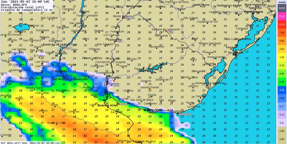
Monday 3: Temperate to warm. Increased cloudiness. Deteriorating from the Southwest starting in the afternoon with storms and rainfall. Figure 2. Map forecast for 6:00 p.m. local time. Temperatures are indicated in degrees Celsius according to numerical values on the map. Precipitation in millimeters per hour according to color scale. NOAA GFS model data.
–
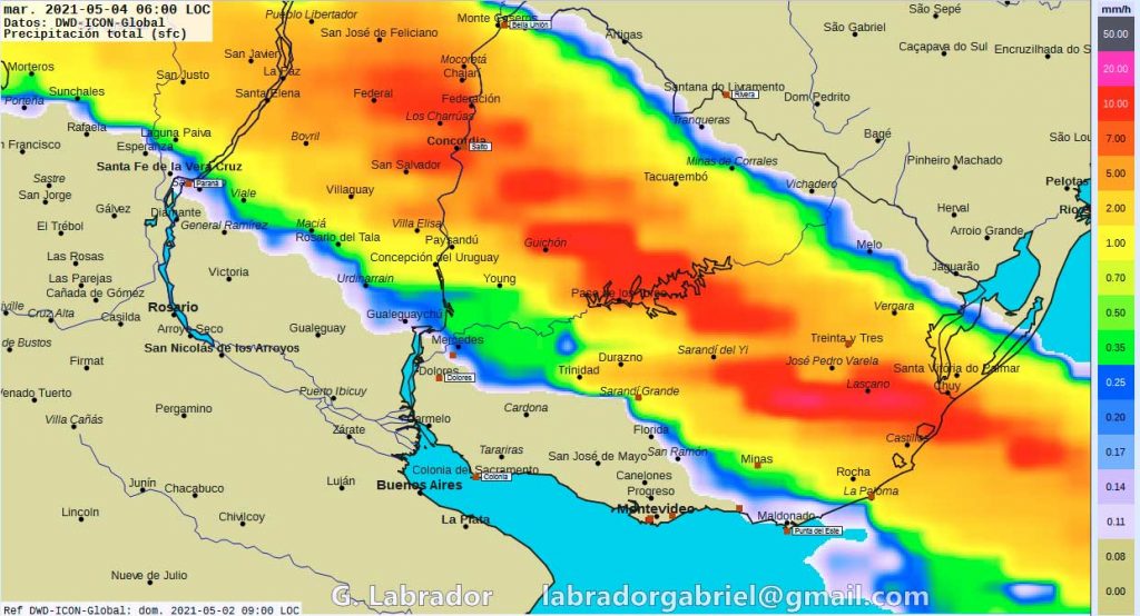
Tuesday 4: Covered with storms and rains since dawn. Partially improving from the Southwest, with strong winds from the South sector and lower temperatures. Figure 3: Map forecast for 06 hours. Data from the German Meteorological Service, ICON model. Rain intensity in millimeters per hour according to the color scale on the right.
–
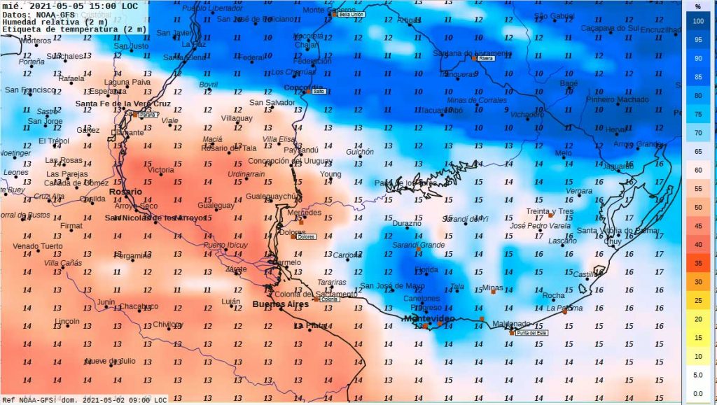
Wednesday 5: Cold to cool and windy with variable cloudiness and periods of overcast. Persistence of isolated showers and scattered drizzles. Mists and mists. Getting better. Figure 4: Map forecast for 3:00 p.m. NOAA data and GFS model. Predicted air temperatures at 2 meters from the surface in degrees Celsius; relative humidity in percentage according to the color scale on the right.
–
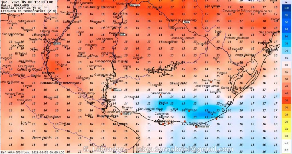
Thursday 6: Cold in the morning to cool in the afternoon with clear and somewhat cloudy skies. Mists and morning mists. Figure 5: Map forecast for 3:00 p.m. Predicted air temperatures at 2 meters from the surface in degrees Celsius; relative humidity in percentage according to the color scale on the right. NOAA data and GFS model.
–
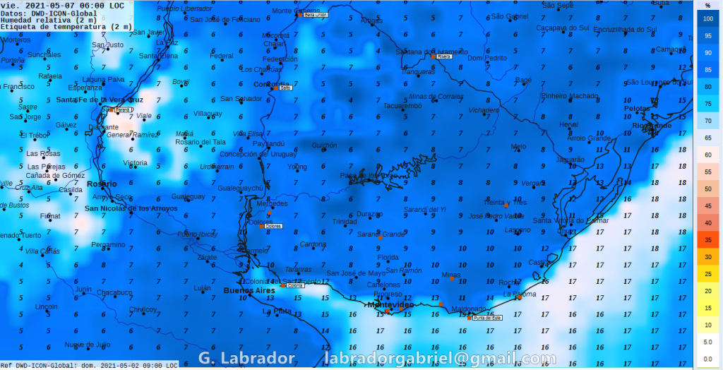
Friday 7th: Very cold to cool in the morning, slightly warm and sunny in the afternoon. Morning mists and mists. Figure 6: Map forecast for 06:00 local hours on May 7. With data from the German Meteorological Service model ICON. Predicted air temperatures at 2 meters from the surface in degrees Celsius; relative humidity in percentage according to the color scale on the right.
–
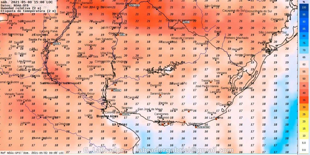
Saturday 8: Cold to cool in the morning with mist and mist. Temperate and sunny in the afternoon. Figure 7: Forecast map for 3:00 pm on Saturday 8. Forecast air temperatures at 2 meters from the surface in degrees Celsius; relative humidity in percentage according to the color scale on the right. With data from NOAA and GFS model.
–
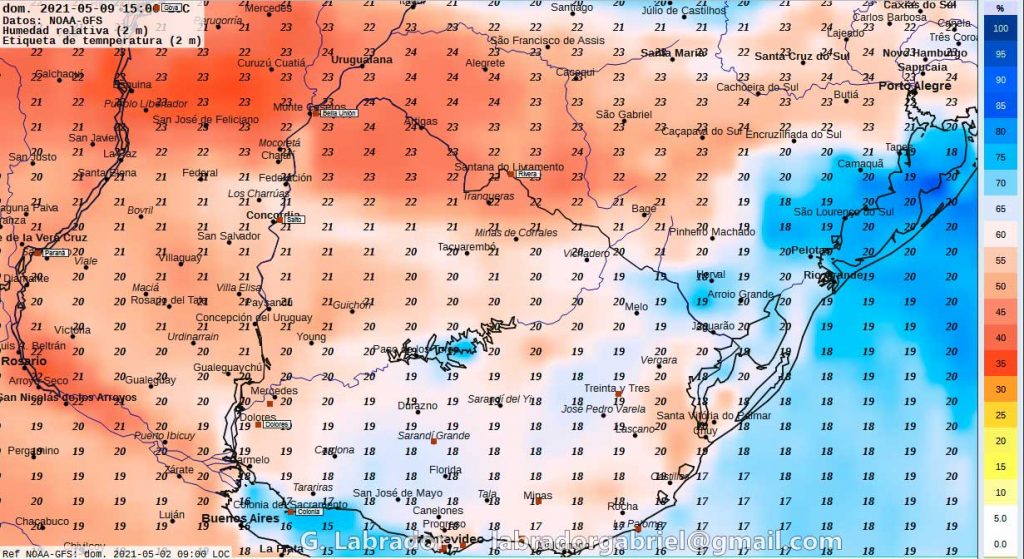
Sunday May 9: Cold to cool in the morning with mists and mists; mild in the afternoon. Figure 8: Map forecast for 3:00 p.m. on Sunday9. Predicted air temperatures at 2 meters from the surface in degrees Celsius; relative humidity in percentage according to the color scale on the right. With data from NOAA and GFS model.
–
VIDEO: Sequence of maps predicted with the German ICON model shows evolution and intensity of rainfall areas in mm / h between Monday 3 and Tuesday 4 May

* Meteorologist Gabriel Labrador
IT MAY INTEREST YOU
–
