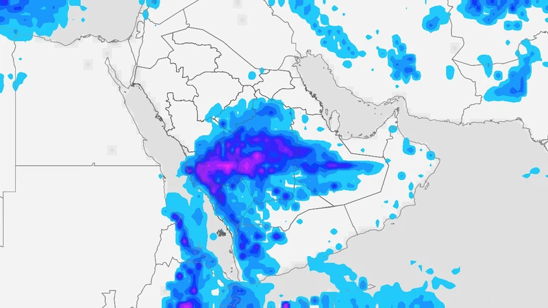
Arab weather – The latest weather forecasts extracted from the outputs of the so-called computer simulations in the Arab Weather Center indicate expectations of a deepening of the upper basin of the Kingdom of Saudi Arabia’s atmosphere in the coming days, and it converges with the extension of the Red Sea depression from the south, in addition to the flow of amounts of moisture with tropical characteristics to our airspace. This weather system will cause, God willing, an intensification of the rainy situation in several regions of the Kingdom, starting from Friday and early next week, with the possibility of a large flow of valleys in some areas.
Friday: Intensification of weather activity and thunderstorms covering large parts of the southwest and central regions of the Kingdom
On Friday, the Kingdom will be increasingly affected by the rainy situation, with the approach of the upper wave, so that moderate rain is expected, interspersed with heavy spots at times, in several parts of the heights and east of the heights of Asir, Al-Baha, Makkah Al-Mukarramah, and the south of Al-Madinah Al-Munawwarah region, with the possibility of flowing valleys and torrential rains in parts from these areas.
The rain clouds gradually extend to the east and northeast to cover several parts of the Riyadh region administratively (especially the western governorates), in addition to parts of the Qassim and Hail regions.
The capital, Riyadh: The best chances of rain are concentrated in the hours after midnight on Friday/Saturday and at dawn on Saturday, and these rains are light to moderate in their entirety.
And the latest analytical readings in the Arab Weather Center indicate that the chances of rain in the capital, Riyadh, are coming at intervals from the afternoon hours on Friday, with occasional activity in the speed of surface winds that raise dust and dust. And the same readings indicate that the best of these opportunities will be the hours after midnight (Friday / Saturday night) and dawn on Saturday, and these rains will be light to moderate in most of them, God willing.
Mecca and its heights under surveillance on Saturday!
And it is expected that an additional intensification of the activity of cumulus clouds will occur on the southwestern highlands on Saturday, as it is expected, God willing, that the opportunity will be created in the afternoon and evening hours for the multiplication of thunderstorm clouds over large parts of the heights and east of the heights of Makkah Al-Mukarramah, Al-Baha and Asir, and they will be accompanied by These clouds, with medium to heavy rains, cause valleys to flow and torrential rains, in addition to a rise in the water level on the roads in some areas. It is not excluded that some scattered rain clouds will extend to parts of the coasts of Makkah Al-Mukarramah, including neighborhoods of Jeddah Governorate, especially the northern and eastern ones.
It is also expected that moderate rain will fall in its entirety, but it will be interspersed with some heavy spots at times on Saturday in parts of Najran and some southern and western governorates of Medina, in addition to several parts of the Riyadh region administratively (especially the southwestern and western governorates).
And it is possible that local clouds will multiply, accompanied by light to moderate rains, in limited parts of Al Sharqiyah, Al Qassim and Hail.
God knows.
