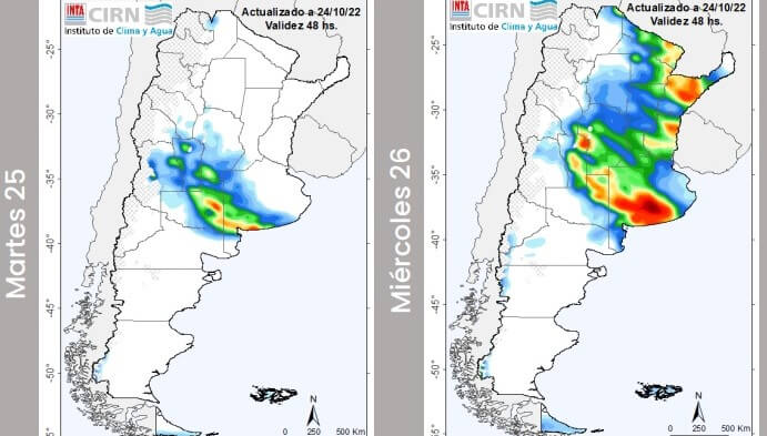
The perspective of abundant rains for the center of the country released by the Buenos Aires Cereals Exchange, it would finally be confirmed in the next few hours, according to various agroclimatic reports known this Monday.
“Tuesday and Wednesday storms of varying intensity will occur in central and western Argentina. Especially in the sectors of the provinces of San Luis, Córdoba, La Rioja, La Pampa and Buenos Aires. They can be strong, with gusts and hail ”, indicated the National Meteorological Service (SMN).
⚠️⛈️ Tuesday and Wednesday will be recorded #storms of varying intensity in central and western Argentina. Especially in the sectors of the provinces of San Luis, Córdoba, La Rioja, La Pampa and Bs as they can be strong with gusts and hail.https://t.co/GRjfngol65 pic.twitter.com/HqjVswZ8ns
– SMN Argentina (@SMN_Argentina) October 24, 2022
For its part, the Weekly Agrometeorological Report of National Institute of Agricultural Technology (INTA) reports that “between Tuesday and Wednesday a cold front is expected to pass over the center and north of the country”, which “would be accompanied by abundant cloud cover and winds from the north sector, which will rotate from moderate to strong from the south and south-west sector” .
In this scenario,there is probability of rain and thunderstorms of varying intensity on Cuyo (south), Pampean region, Santiago del Estero and NEA; some locally intense with abundant waterfallsgusts and occasional hailstorms fall on San Luis, La Pampa, Buenos Aires (south and west), Entre Ríos, Corrientes and Formosa ”, adds INTA.
On the other hand, a Twitter user who tracks adverse weather events in central Argentina and Uruguay estimated that there is “a beautiful rainy and widespread event just around the corneron the central area of the country, for the whole day of Tuesday ”, which would leave accumulations of over 50 millimeters in some areas of La Pampa, central and western Buenos Aires, southern Cordova and San Luis.
#EVENT | A beautiful rainy and widespread demonstration at the gates, in the central area of the country, for the whole day tomorrow.
We predict strong and violent storms leaving +50 mm punctual accumulations in La Pampa, central and western Buenos Aires, southern Cba. and San Luigi. 🥳 pic.twitter.com/8Brbhtdddds
– MeteoFedex Weather ⛈ (@MeteoFedex) October 24, 2022


