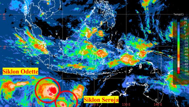
Jakarta, CNBC Indonesia – The Meteorology, Climatology and Geophysics Agency (BMKG) revealed that currently Seroja Tropical Cyclone is still in the Indian Ocean region with a movement towards the southwest further away from Indonesian territory. However, several areas are said to be potentially affected.
“The maximum wind speed of Seroja Tropical Cyclone is around 40 knots (75 km / hour),” said BMKG Deputy for Meteorology Guswanto, in his official statement, Saturday (10/4/2021).
Meanwhile, cyclone 90S seeds, which since April 2, 2021, coincided with the current Seroja cyclone seeds (Friday. 9 April 2021 at 07.00 WIB) has grown into Odette Tropical Cyclone in the Indian Ocean, precisely at 14.2LS and 107.7 positions. BT or about 780 km south southwest of Cilacap.
The maximum wind speed at the center of circulation of Tropical Cyclone Odette is up to 45 knots (approx. 80 km / h) and the air pressure at the center of circulation is 990 hPa (Hecto Pascal, unit of air pressure).
The Australian Bureau of Meteorology (BoM) Tropical Cyclone Warning Center (TCWC) gave the name of the tropical cyclone Odette because the position of the tropical cyclone is in the area of Australian responsibility.
BMKG predicts, in the next 24 hours, it is estimated that Tropical Cyclone Odette will continue to move south-southwest away from Indonesian territory with an intensity that tends to weaken.
The existence of Seroja Tropical Cyclone and Tropical Cyclone Odette in the next 24 hours will have an indirect impact in the form of:
– Potential rain with moderate to heavy intensity in the next 24 hours which can be accompanied by lightning and strong winds in Lampung, Central Java, East Java, Bali. This potential will certainly not be as extreme as when the Seroja tropical cyclone was still near the East Nusa Tenggara (NTT) region.
– Meanwhile, the potential impact of high waves can occur for the next 2 days
– Wave height of 1.25-2.5 meters is likely to occur in the Java Sea, Southern Waters of Bali Island to Sumba Island, Bali Strait – Lombok Strait – Alas Bag Strait. South, Sumba Strait Bag. West, Savu Sea Bag. South, Southern Waters of P. Sawu, and Southern Waters of P. Rotte.
– Wave height of 2.5-4.0 meters is likely to occur in the waters of P. Enggano – Bengkulu, West Lampung waters, West Indian Ocean Kep. Mentawai to Lampung, West and Southern Sunda Strait, Southern Waters of Java Island, and South Indian Ocean from NTB to NTT.
– Wave height of 4.0-6.0 meters is likely to occur in the South Indian Ocean, Java – Bali.
“BMKG continues to monitor the development of potential extreme weather in Indonesia. The public is urged to be careful about the potential for strong winds and heavy rains which are still likely to occur in some areas and to be aware of potential impacts such as floods, landslides and flash floods,” Guswanto said.
(bag bag)
– .


/cloudfront-eu-central-1.images.arcpublishing.com/larazon/ZVYIC4GOD5DKRE663YE4V5FDIE.jpeg)