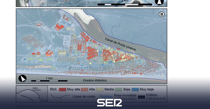
The impact of a tsunami off the coast of Huelva would cause the flooding of 20 percent of the coastline under a sheet of between 7.5 and 10 meters of water above sea level.
In Huelva capital only 3 percent of the surface would be built in areas of high danger and Punta Umbría, with 42 percent, would be the most affected town of the entire coast with very high danger.
The waves would advance inland several kilometers through the river valleys. They would see affected the beacon towers, Doñana and Marísmas del Odiel, or patrimonial emblems such as the Muelle del Tinto or the Tharsis mineral loading dock.
The report, published in the latest issue of the magazine of the geological society of Spain, is called ‘analysis of the vulnerability of coastal populations in the province of Huelva to tsunamis’. It is a joint work of the Department of Earth Sciences of the Onubense and the University of Atacama, From Chile. On the part of the Onubense teachers have participated Joaquín Rodríguez Vidal, Francisco Ruiz and María Luz González Regalado. The study has advanced this morning the digital diariodehuelva.es.
In the work, the damage to the constructions of the coastal populations has been evaluated by proposing an escenario similar to the one that occurred in the Lisbon earthquake of 1755. It is the worst possible situation. The conclusions show that the waves would advance inland for several kilometers through the river valleys, flooding the beaches and estuaries completely. Almost 20 percent of the exposed coastline would be flooded under a sheet of water between 7.5 and 10 meters above sea level. This space will include heritage elements such as torres almenaras, the mining bridges of the Riotinto and Tharsis Companies, or places of high ecological value such as National and Natural Park of Doñana and the Marismas del Odiel. All of them would be in the high danger zone and would be damaged.
The forest masses associated with the coastal dunes would receive the direct impact of the waves and at the same time attenuate the energy of the event in the areas located inland.
The most important potential damages would be registered in the populations of the western sector of the province. In Isla Canela, Isla de El Moral or Punta Umbría, more than 50 percent of the constructions present high and very high vulnerabilities. In all of them, multi-storey buildings, deep foundations and solid materials, dedicated to tourism in high seasons, would have low and very low vulnerability. However, single-family houses, with 1 or 2 floors and bricks, would present high and very high vulnerability.
The coastal date of Punta Umbría would also be completely surpassed by the waters, although in some areas the flood would not exceed 3 meters.
In Huelva capital only 3 percent of the surface would be built in highly dangerous areas. The city is located inside the estuary of the Tinto and Odiel rivers. It is protected from the flooding that would cause a tsunami by the Odiel and Burro marshes, as well as by the coastal arrows of Punta Umbría and Punta Arenillas. Around 40 percent of the territory would be potentially affected by marine flooding, with only 4.2 percent of the surface exposed to high danger from tsunami.
The towns that have a higher percentage of exposed surface, within the different degrees of danger, are Punta Umbría (100%), Punta del Moral (100%), El Rompido (57%), La Antilla (55%) and Huelva (37%).
The example of Punta Umbría represents the most paradigmatic case of an urban nucleus exposed to the destructive action of a tsunami in the Gulf of Cádiz. 100% of its extension would be affected by the tsunami although only 3% of the constructions are located in areas of very high danger
These types of studies are very suitable tools for managing land use planning, raising awareness among the population and preparing evacuation plans, all of which are designed together to mitigate the damage caused by a future tsunami in the Gulf of Cádiz.
–


