Tropical Storm Kong-Rey Enters PAR: What to Expect This Week
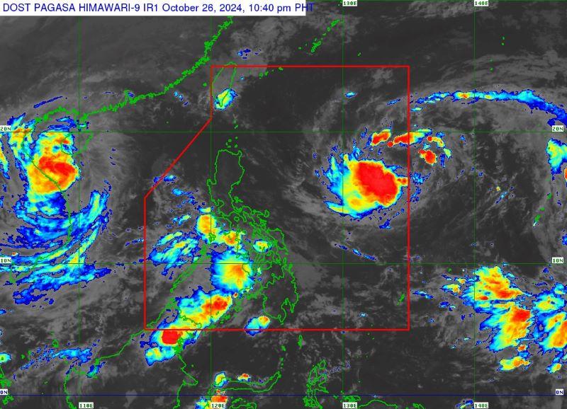
Tropical Storm Kong-Rey, locally known as "Leon," has made its way into the Philippine Area of Responsibility (PAR) as of Saturday evening, according to the Philippine Atmospheric, Geophysical and Astronomical Services Administration (PAGASA). As the 12th tropical cyclone to enter the region in 2023, Leon poses potential weather shifts for various areas in the Philippines, though a direct impact seems unlikely.
Current Status and Forecast
At 10 p.m. on Saturday, Kong-Rey was positioned approximately 1,355 kilometers east of Central Luzon. The storm currently has maximum sustained winds of 65 kilometers per hour (km/h) and gusts reaching 80 km/h. Moving westward at a speed of 25 km/h, Leon is expected to intensify into a severe tropical storm by Sunday evening or early Monday, possibly evolving into a typhoon by Tuesday morning.
PAGASA has advised that while Leon is "unlikely" to directly affect the country, its outer rainbands may reach Extreme Northern Luzon, depending on its trajectory over the Philippine Sea. State meteorologists emphasize the importance of closely monitoring these storm movements:
"This tropical cyclone is forecast to remain far from the Philippine landmass. However, the track forecast may still shift with the limit of the forecast confidence cone," a PAGASA official stated during a briefing.
Weather Alerts and Impacts
PAGASA has warned that Signal No. 1 could be raised over parts of Cagayan Valley and the northeastern Bicol Region as early as Sunday afternoon or evening. The highest wind signal that may be hoisted during Leon’s passage is Signal No. 2. Areas expected to experience strong to gale-force gusts include Catanduanes, Northern Samar, Eastern Samar, and Dinagat Islands.
In anticipation of the storm, PAGASA forecasts moderate to rough sea conditions over northern and eastern Luzon, as well as the eastern seaboard of the Visayas. This could lead to hazardous situations for fishermen and small vessels in these regions, necessitating caution as conditions develop.
Potential Influence on Technology and Economy
The passage of storm systems like Kong-Rey can also impact technology and business sectors, particularly in terms of telecommunications and supply chains. With previous storms affecting connectivity and operations, businesses and tech-savvy residents are advised to prepare for potential internet and power disruptions.
For those in technology sectors, it’s worth noting that disruptions during storm conditions can slow down innovation. Collaboration tools like Slack and Zoom become vital during these periods, allowing companies to maintain productivity through remote communication. Companies in logistics and distribution should consider contingency planning, potentially shifting operations or staffing based on weather forecasts.
Community Preparedness and Response
Officials urge communities to stay updated with weather advisories, and local governments are preparing response protocols in anticipation of Leon’s effects. Educational campaigns focusing on storm preparedness, such as securing properties and preparing emergency kits, can significantly mitigate adverse outcomes during storm events.
"Preparation is key in mitigating the impact of tropical storms. Ensuring that your family has a plan and emergency supplies can make a difference," a public safety official noted.
Engage with Us
As Tropical Storm Kong-Rey, or Leon, progresses, we will continue to provide updates on its development and its potential impacts on the Filipinos. For more information on storm preparedness and real-time updates, visit the official PAGASA website.
What preparations are you making in response to the incoming storm? Share your thoughts and your storm preparations in the comments below!
For further reading, stay tuned to reliable sources like the Weather Channel and TechCrunch for the latest news on storms and their effects on technology and economy.


