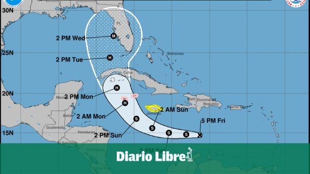
The director of the National Bureau of Meteorology (Onamet), Gloria Ceballos, reported that the Tropical depression Number 9 will become a tropical storm in the next few hours, and due to its trajectory, it will indirectly affect the southeastern and southwestern regions of the country.
The Miami National Hurricane Center report details in its latest report that the tropical depression is located 515 miles (830 km) east of the Jamaican capital, Kingstonand 1,015 miles (1,635 km) from Havana and driving with maximum sustained winds of 35 miles per hour (55 km / h).
On the track, the cyclone is expected to travel through the central Caribbean until Saturday, pass south of Jamaica on Saturday night and Sunday, and approach the Cayman Islands on Sunday night and early Monday. Monday night he could reach Florida.
While from Onamet it was reported this morning that the indirect effects of this tropical depression They generated light to moderate rainfall, sometimes heavy with electric storms and isolated gusts of wind over several provinces located in the northeastern and southeastern regions (including Santo Domingo and the National District).
The Dominican Meteorological Report predicts that this rainfall will be more frequent and intense as the afternoon and early night progresses, gradually spreading to several locations in the southwest, Cibao, northwest and central mountain ranges.
saturated soils
although the Tropical depression o possible tropical storm Ian does not represent a danger to the country, the soils are saturated by the recent passage of Hurricane Fiona, which is why Ceballos warned that in this situation “any amount of precipitation generated by the cloudy fields of this Tropical depressionIt will cause flooding, which is why the recommendations of the COE and the warnings that have been issued are important ”.
28 provinces on alert
When the advance of the natural phenomenon became known, the Emergency Operations Center (COE) alerted 28 different provinces of possible flooding of rivers, streams and ravines, as well as urban flooding and landslides.
In yellow warning are the National District and the provinces: Hato Mayor, San Pedro de Macorís, La Romana, La Altagracia, Samaná, Barahona, Peravia, Azua, San Juan, El Seibo, La Vega, María Trinidad Sánchez, Duarte (especially Bajo Yuna), San Cristóbal, Pedernales, San José de Ocoa and Santo Domingo.
In green They are: Sánchez Ramírez, Santiago, Monte Plata, Monsignor Nouel, Valverde, Santiago Rodríguez, Montecristi, Sisters Mirabal, Espaillat and Puerto Plata.
This Saturday, the country will continue under the indirect effects of Tropical depressionModerate to heavy downpours will therefore occur over the south-east, north-west, the Central Cordillera and the border area, especially in the afternoon.
ermione
This afternoon the Tropical depression number 10 developed into tropical storm Hermine, being number 8 of this one Hurricane Season 2022it is located about 470 kilometers north-east of the Cape Verde Islands, has maximum sustained winds of 65 km / h and moves at about 17 km / h.
Due to its position and its displacement, it does not represent a danger to the country.
Shower area monitoring
Onamet also said it continues to monitor an area of downpours with electrical thunderstorms associated with an active tropical wave, located thousands of kilometers west / southwest of the Cape Verde Islands, currently with low potential (20%). to become a tropical cyclone within the next 48 hours.
Due to its position and location, at the moment it does not represent a danger for the Dominican territory.


